Digital Road Management for Your County

Capture road conditions, plan maintenance, and keep budgets on track, all in one system

Eine Landstraße zwischen Feldern und Bäumen

A Standard for All County Across the US

bastrop county, tx
Bastrop County

Texas

gibson county,  in
Gibson County

Indiana

lake county, ca
Lake County

California

gloucester county
Gloucester County

New Jersey

middlesex county
Middlesex County

New Jersey

greene-county-seal
Greene County

New York

gwinnett
Gwinnett County

Georgia

The Biggest Challenges for Counties

Missing Data

Without up-to-date information, it's nearly impossible to plan investments and repairs effectively.

Fragmented Responsibilities

Different data sources across public works, road crews, and administrations make coordination difficult.

High Effort

Multiple Excel lists and time-consuming approvals slow down processes and waste valuable time.

Turn Road Challenges Into Results

A folder containing many files is displayed virtually in front of a person. It visualizes the dataset provided by vialytics.

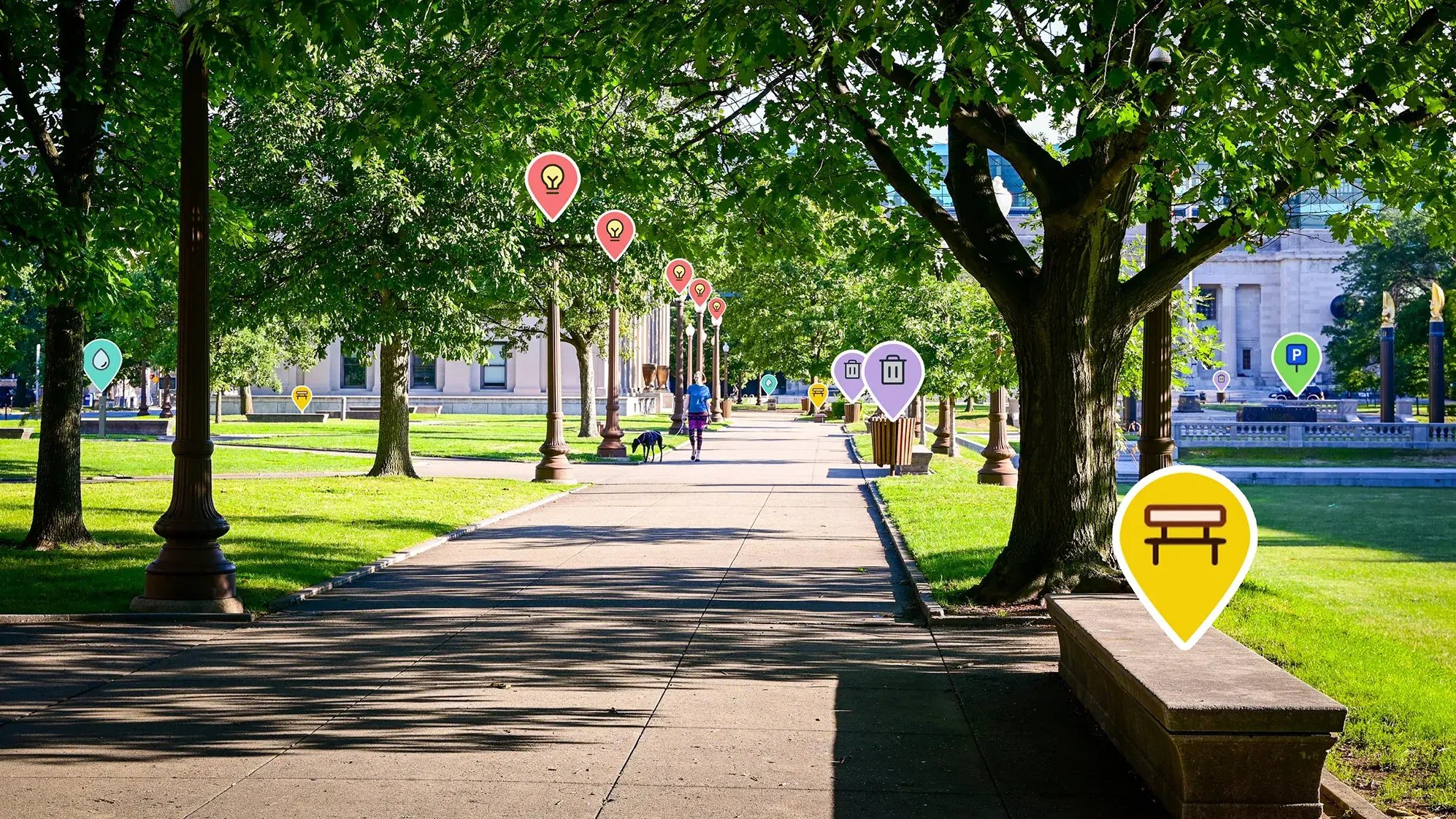
Smarter Data, Better Decisions

Turn scattered information into one clear foundation and make confident, data-driven choices. 

A woman shakes hands with someone. Collaboration between different departments is visualized thanks to vialytics.

Seamless Collaboration

Bring every department together in one system for faster planning and smoother workflows. 
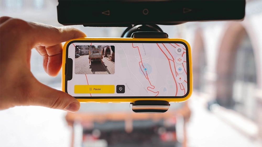
The vialytics app is actively used on an iPhone attached to a windshield.

Effortless to Use

A simple, intuitive app that works right away, no long trainings, just instant productivity. 

Smarter Road Network Mapping

Many counties plan and evaluate their road networks using a road network mapping model. vialytics builds on this framework to make your data instantly usable. 

  • Structured for Your Road Network - Data is organized to fit the way your network is already mapped.

  • Pinpoint Accuracy - Capture exact location details for road condition data.

  • Easy-to-Understand Visuals - Clear maps and dashboards for agencies, decision-makers, and the public.

  • Seamless GIS Integration - Easily transfer data into existing systems.

Learn More About Your Options

An illustration of a map visualizing the node-edge model

Value for Every Stakeholder in the County

👷 Public Works & Road Crews

  • Road conditions visible directly in the field

  • Document actions instantly through the app

  • Smooth collaboration across departments

🏢 Administration Offices

  • Meet traffic safety obligations with confidence
  • Access condition data and planning overviews anytime

  • Seamlessly integrate with existing tools

👤 County Leaders & Decision-Makers

  • Visual reports that support political discussions

  • Clear overview of road conditions and funding needs

  • Transparent communication with residents

vialytics in Action

234x Faster Road Insights with AI

Manually documenting road conditions is time-consuming and labor-intensive. 

In a real-word test, surveying just 100 meters (328 feet) of roadway by hand took nearly 47 minutes. With vialytics, the same stretch only took 12 seconds. 

For counties managing large road networks, this means: 

  • Faster insights
  • Instant comparison
  • A reliable, objective data foundation
A graphic showing that road condition surveys can be completed much faster with vialytics than with manual inspections.

Frequently Asked Questions

Does the vialytics system also detect damage to road markings and guardrails?

Currently, the vialytics system does not yet detect damage to road markings and guardrails. 

Right now, the focus is on the automated detection and assessment of pavement damage such as potholes, cracks, rutting, and surface wear. Our development team is continuously improving the AI algorithms and image processing technology

The goal is to expand capabilities to reliably identify and document issues with lane markings, guardrails, and other critical roadway safety features. This will provide counties and municipalities with an even more comprehensive solution for digital road maintenance, traffic safety, infrastructure management. 

Is it possible to integrate your road network mapping model into the vialytics web system?

Yes, that's possible. If your road network mapping model is available as a Shapefile, we can easily integrate it into the vialytics web system. This allows you to work with your own stationing and align road data precisely with your existing infrastructure. 

Integration of your custom network model provides several advantages: 

  • Customer Referencing - Use your own measurement system without having to adapt to standardized formats.
  • Seamless Data Connection - Directly link your existing GIS data with detected road condition information. 
  • Tailored Analysis & Reporting - Gain a more accurate data foundation for planning, maintenance, and investment decisions. 

This way, the vialytics system adapts to the needs of our county or agency, supporting efficient road and infrastructure management. 

How often should county roads be inspected to better plan maintenance work?

To ensure proactive road maintenance, its important to regularly monitor the condition of county roads. With the vialytics system, this can be done efficiently - whether or not you already have condition data available. 

  • With existing condition data - Current datasets can be enhanced with real-world, up-to-date insights from vialytics, creating a complete picture of road conditions. 
  • Without existing condition data - vialytics can capture the full condition of your road network digitally and automatically - quickly, efficiently, and without additional workload for your staff.

By continuously monitoring road conditions, damages can be identified early and maintenance needs planned proactively. This not only improves traffic safety but also helps optimize budgets and extend the life of your infrastructure. 

How can road data be centralized and shared to manage projects more effectively?

In many counties and municipalities, information about road conditions, planned construction, maintenance work, or incidents are scattered across different departments. These data silos makes collaboration difficult and prevent a complete view of the road network. 

With the vialytics web system, all relevant road data can be stored and managed in one central place. This ensures that everyone - from public works supervisors to engineering and administration - has transparent, up-to-date information at all times. 

The benefits of centralized road data with vialytics:

  • Shared access to road data across departments
  • Better coordination of projects, such as resurfacing or work zone management
  • Increased transparency around conditions, planned projects, and budget use
  • More efficient processes by reducing duplicate work and information gaps

This way, vialytics helps counties manage their road infrastructure digitally, plan ahead for maintenance needs, and continuously improve roadway safety.

This Right System for Your County

Road Management for Your County

Together, we modernize and digitalize your road management. Get in touch with us today!